LIDO IN THE CONTEXT OF URBAN CLIMATE AND ITS POTENTIAL TO MITIGATE THE IMPACTS OF CLIMATE CHANGE
Juraj Holec
Urban populations around the world continue to grow. While in 1950 they
represented 30 % of the global population, in 2018, the urbanization rate grew
to 55 %, and according to UN estimates, 68 % of the global population will live
in cities by 2050. In addition to others, this results in increased
construction on land previously comprised of arable soil, forests and other
green areas. The process of placing an impervious surface, i.e., a structure or
an asphalt road, on a soil surface is called soil sealing. The expert community notes the following negative
aspects of this phenomenon: it limits the positive functions of the soil and
contributes to changes in the microclimate of the location; water from
precipitation is not retained, but quickly drains into rain water sewer systems,
or if they are clogged, it may collect in locations such as vehicular
underpasses, pedestrian underpasses or the bottoms of slopes. Therefore,
replacing impervious surfaces with semi-permeable surfaces or creating water
retaining measures is becoming a trend.
The climatic phenomenon of the urban heat island, which occurs in urbanized areas and features higher temperatures in comparison with the surrounding rural landscape, is mentioned in the context of the urban environment and sealed areas. This phenomenon was first described in the 19th century in London by Luke Howard who observed and measured differences in air temperature between urban and adjacent rural environments. However, the term itself appeared for the first time in the 1940s, in a study of Bath, England by Balchin and Pye. Thus, a city can be characterized as an island of relatively warmer air in a sea of relatively colder air.
An urban heat island is created by replacing a natural landscape with artificial materials. The principal causes are connected with the higher absorption of solar radiation thanks to the multiple reflection and absorption of radiation by walls of buildings and vertical surfaces in a city, the retention of infra-red radiation in closed streets, the greater absorption of heat by paved and artificial surfaces, as well as the production of heat from transportation, manufacturing processes and heating [1]. As mentioned in the first paragraph, water is relatively quickly drained into rain water sewer systems and its ability to cool down the surrounding air by evaporation is decreased in this type of environment. Equally, the number of trees in a city has an impact on the climate of a city and the microclimates of its individual districts. The importance of this research is also growing in the context of global climate change, regarding the overall warming of the earth’s atmosphere and the subsequent intensity of extreme weather phenomena and summer heat waves among others [2]. Thus, an urban heat island is manifested not only in the temperature of the air, but in the temperature of surfaces as well as soil and groundwater.
The substantial difference between undeveloped soil and anthropogenic surfaces lies in the fact that overheated artificial surfaces accumulate a large amount of heat in an urbanized environment which then heats up the surroundings in the form of radiating heat exchange even after sunset. On the contrary, vegetation does not hold heat in the summer. After the effective reduction of direct radiation (in times of negative energy balances) and after sunset, it cools down relatively quickly and thus does not act as a secondary heat source. Thus, the effects of urban heat islands are most markedly manifested in the evening and night hours, when the undeveloped rural landscape cools down quicker than the developed urban landscape. Furthermore, there is a relation between the size of the city and the intensity of the urban heat island. In the case of Bratislava, there may be differences of several degrees of Celsius between the city center and its outskirts, which has a negative effect on the a person’s comfort and the ability of the organism to regenerate during sleep, especially during summer nights.
From the perspective of the microclimate, trees are also important because they cast shade and provide a place for people to hide from direct sunshine. Evapotranspiration, when the environment cools thanks to the evaporation of water from trees, is another positive effect, perhaps even more significant than direct shade. A large tree can evaporate up to 350 - 400 liters of water a day. This is a cooling effect equal to that of four air conditioning units running for 20 hours. Research in California showed that temperatures in urban districts with old trees were 2 to 4°C lower than temperatures in districts lacking trees [3]. In addition, trees absorb carbon dioxide (CO2) when breathing and produce oxygen. They also work as a filter of impurities and protect against soil erosion. If we wanted to prove these tree qualities in the case of Bratislava, it would be enough to imagine where the conditions are more pleasant on a hot summer day: Hlavné Square or Hviezdoslavovo Square?
The role of larger green areas created by trees, i.e., parks, or forests near cities, is also important for mitigating the negative aspects of urban heat islands, as they act as local cool islands within an urban heat island. The availability of such local cool islands for the urban population has recently attracted the attention of local governments, the scientific community and urban planners as they search for adaptation measures to deal with climate change. Bratislava’s cool islands include Horský park, Sitina, Medická záhrada and the city forests, which include the area of forests and greenery along the Danube: starting with Pečniansky les, through Sad Janka Kráľa and Lido, which we will address in this text, Soví les and the continuing zone of alluvial forests on both sides of the Danube River. With a slight exaggeration, we could say that it represents an entire “archipelago” of cooler areas, where we can find respite from the heat on summer days.
![]() Fig 1:
Points
of field air temperature measuring of July 21, 2022
Fig 1:
Points
of field air temperature measuring of July 21, 2022
I would like to point out in greater detail the area of Lido and its potential to be a cooler spot in the middle of city. I carried out my own air temperature measurements and examined the temperatures of surfaces acquired from satellite data and modeled values of air temperature with the current state of the location and that of its proposed development.
I conducted the field air temperature measurement on July 21, 2022, in the middle of a heat wave, during which temperatures measured at the Bratislava-airport exceeded 30 °C on eight consecutive days from July 18 to July 25 . The temperature on July 21st was 36.4 °C - the warmest day of the heat wave. I carried out the measurements between 5:15 p.m. and 5:40 p.m and selected a route with four measuring points from the developed section of Petržalka at the intersection of Šustekova and Lužná streets (Point No. 1) through the area of Lido (Point No. 2 in the small forest near Kočánková Street), towards the Danube River (Point No. 3 in the alluvial forest near the Danube) and then across the old bridge into the old town to Primaciálne Square (Point No. 4). This profile of measuring demonstrated the temperature differences among the locations which are depicted in the map on Fig. 1. The measuring locations are photographically documented in Fig. 2. The densely developed location on Primaciálne Square with a temperature of 35.8 °C was the warmest. The second warmest was the developed zone at the intersection of Lužná and Šustekova streets in Petržalka, Bratislava (35 °C), while the natural locations were cooler: Point No. 2 in the small forest near Kočánková showed 32.8 °C and Point No. 3 in the more dense forest by the Danube River had a temperature of 31.9 °C. Thus, the difference between the warmest and coolest locations was almost 4 °C and the Lido site was the local cool island.
Fig. 2: Photographs of the points of field air temperature measuring.
![]()
(1) Šustekova/Lužná Street
![]()
(2) Forest near Kočánková
![]()
(3) Forest by the Danube
The climatic phenomenon of the urban heat island, which occurs in urbanized areas and features higher temperatures in comparison with the surrounding rural landscape, is mentioned in the context of the urban environment and sealed areas. This phenomenon was first described in the 19th century in London by Luke Howard who observed and measured differences in air temperature between urban and adjacent rural environments. However, the term itself appeared for the first time in the 1940s, in a study of Bath, England by Balchin and Pye. Thus, a city can be characterized as an island of relatively warmer air in a sea of relatively colder air.
An urban heat island is created by replacing a natural landscape with artificial materials. The principal causes are connected with the higher absorption of solar radiation thanks to the multiple reflection and absorption of radiation by walls of buildings and vertical surfaces in a city, the retention of infra-red radiation in closed streets, the greater absorption of heat by paved and artificial surfaces, as well as the production of heat from transportation, manufacturing processes and heating [1]. As mentioned in the first paragraph, water is relatively quickly drained into rain water sewer systems and its ability to cool down the surrounding air by evaporation is decreased in this type of environment. Equally, the number of trees in a city has an impact on the climate of a city and the microclimates of its individual districts. The importance of this research is also growing in the context of global climate change, regarding the overall warming of the earth’s atmosphere and the subsequent intensity of extreme weather phenomena and summer heat waves among others [2]. Thus, an urban heat island is manifested not only in the temperature of the air, but in the temperature of surfaces as well as soil and groundwater.
The substantial difference between undeveloped soil and anthropogenic surfaces lies in the fact that overheated artificial surfaces accumulate a large amount of heat in an urbanized environment which then heats up the surroundings in the form of radiating heat exchange even after sunset. On the contrary, vegetation does not hold heat in the summer. After the effective reduction of direct radiation (in times of negative energy balances) and after sunset, it cools down relatively quickly and thus does not act as a secondary heat source. Thus, the effects of urban heat islands are most markedly manifested in the evening and night hours, when the undeveloped rural landscape cools down quicker than the developed urban landscape. Furthermore, there is a relation between the size of the city and the intensity of the urban heat island. In the case of Bratislava, there may be differences of several degrees of Celsius between the city center and its outskirts, which has a negative effect on the a person’s comfort and the ability of the organism to regenerate during sleep, especially during summer nights.
From the perspective of the microclimate, trees are also important because they cast shade and provide a place for people to hide from direct sunshine. Evapotranspiration, when the environment cools thanks to the evaporation of water from trees, is another positive effect, perhaps even more significant than direct shade. A large tree can evaporate up to 350 - 400 liters of water a day. This is a cooling effect equal to that of four air conditioning units running for 20 hours. Research in California showed that temperatures in urban districts with old trees were 2 to 4°C lower than temperatures in districts lacking trees [3]. In addition, trees absorb carbon dioxide (CO2) when breathing and produce oxygen. They also work as a filter of impurities and protect against soil erosion. If we wanted to prove these tree qualities in the case of Bratislava, it would be enough to imagine where the conditions are more pleasant on a hot summer day: Hlavné Square or Hviezdoslavovo Square?
The role of larger green areas created by trees, i.e., parks, or forests near cities, is also important for mitigating the negative aspects of urban heat islands, as they act as local cool islands within an urban heat island. The availability of such local cool islands for the urban population has recently attracted the attention of local governments, the scientific community and urban planners as they search for adaptation measures to deal with climate change. Bratislava’s cool islands include Horský park, Sitina, Medická záhrada and the city forests, which include the area of forests and greenery along the Danube: starting with Pečniansky les, through Sad Janka Kráľa and Lido, which we will address in this text, Soví les and the continuing zone of alluvial forests on both sides of the Danube River. With a slight exaggeration, we could say that it represents an entire “archipelago” of cooler areas, where we can find respite from the heat on summer days.
 Fig 1:
Points
of field air temperature measuring of July 21, 2022
Fig 1:
Points
of field air temperature measuring of July 21, 2022
I would like to point out in greater detail the area of Lido and its potential to be a cooler spot in the middle of city. I carried out my own air temperature measurements and examined the temperatures of surfaces acquired from satellite data and modeled values of air temperature with the current state of the location and that of its proposed development.
I conducted the field air temperature measurement on July 21, 2022, in the middle of a heat wave, during which temperatures measured at the Bratislava-airport exceeded 30 °C on eight consecutive days from July 18 to July 25 . The temperature on July 21st was 36.4 °C - the warmest day of the heat wave. I carried out the measurements between 5:15 p.m. and 5:40 p.m and selected a route with four measuring points from the developed section of Petržalka at the intersection of Šustekova and Lužná streets (Point No. 1) through the area of Lido (Point No. 2 in the small forest near Kočánková Street), towards the Danube River (Point No. 3 in the alluvial forest near the Danube) and then across the old bridge into the old town to Primaciálne Square (Point No. 4). This profile of measuring demonstrated the temperature differences among the locations which are depicted in the map on Fig. 1. The measuring locations are photographically documented in Fig. 2. The densely developed location on Primaciálne Square with a temperature of 35.8 °C was the warmest. The second warmest was the developed zone at the intersection of Lužná and Šustekova streets in Petržalka, Bratislava (35 °C), while the natural locations were cooler: Point No. 2 in the small forest near Kočánková showed 32.8 °C and Point No. 3 in the more dense forest by the Danube River had a temperature of 31.9 °C. Thus, the difference between the warmest and coolest locations was almost 4 °C and the Lido site was the local cool island.
Fig. 2: Photographs of the points of field air temperature measuring.

(1) Šustekova/Lužná Street

(2) Forest near Kočánková

(3) Forest by the Danube

(4) Primaciálne Square
Satellite shots, where surface temperatures can calculated, are another source of evidence of urban heat islands. We must point out that surface and air temperatures are not the same and do not have to correspond closely; however, surface temperatures also reflect our temperature comfort to a certain extent – it is enough to imagine the difference between standing on a red-hot parking lot, where the temperature of asphalt can be up to 50 °C or on a grassy area with a surface temperature of 25 °C. We can see the demonstration of surface temperatures in the map in Fig. 3. This is is derived from the satellite shot of the Landsat 8 mission, which was taken on April 22, 2018 in the afternoon. Although it was still April, that day was unusually warm, with the maximum air temperature at the Bratislava-airport reaching 27.8 °C. From the map we can observe that the Danube had the coolest surface temperature (15-16 °C). The zone from Pečniansky les through Sad Janka Kráľa, Lido and the alluvial forests along the Danube had surface temperatures between 21 and 23 °C. Surface temperatures in the housing development in Petržalka ranged from 26 to 28 °C; surface temperatures in the historical center of Bratislava exceeded 29 °C, while the highest temperatures were recorded on large parking lots by Aupark and Incheba, which exceeded 30 °C. Thus, surface temperatures also indicate that Lido along with Sad Janka Kráľa and the alluvial forests beyond the Prístavný Bridge are cooler locations which can be used as a “hideaways” on hot days and not only in the summer.
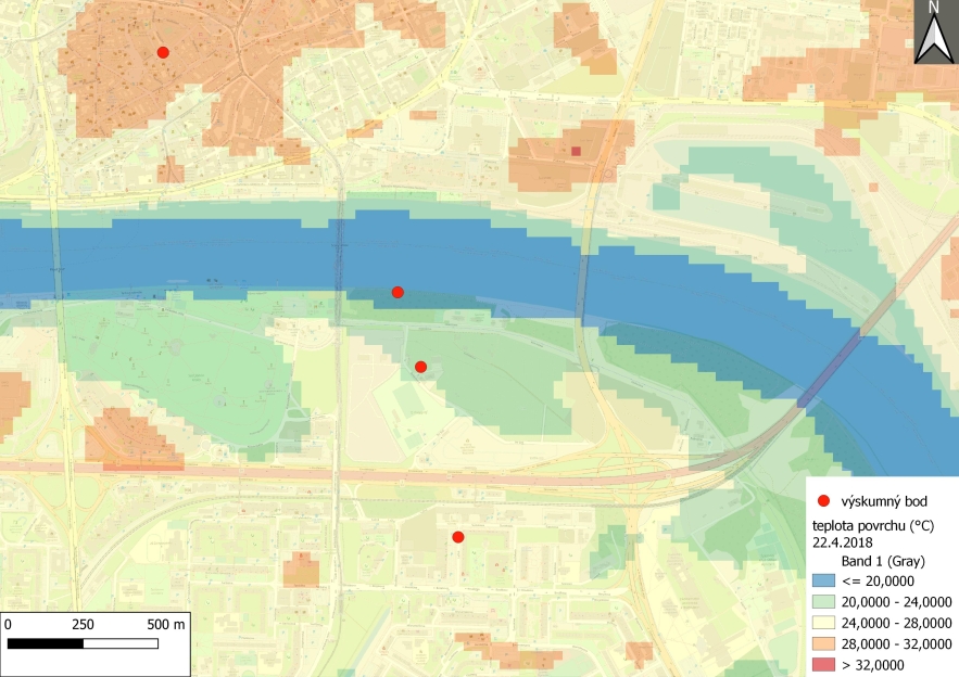 Fig.
3:
Surface
temperature on April 22, 2018 derived from the Landsat 8 satellite shot
Fig.
3:
Surface
temperature on April 22, 2018 derived from the Landsat 8 satellite shot
The modeling of air temperature is the third source through which I demonstrate the significance of the area from the perspective of urban climates. For this purpose I used the MUKLIMO_3 model, which was developed by the German Meteorological Service and which is primarily designated for studying urban climates. We used this model at SHMÚ (Slovak Hydrometeorological Institute) to study the climate of several Slovak cities and towns. I modeled the course of temperature on a summer day (August 18, 2018) from the heat wave which hit Bratislava in August of that year. One of the materials for the model is the land cover or land use. Here I ran the model in two variants: in the case of the current land use (i.e., with the Lido location partially covered by forests and gardens) and in case of its projected state after the planned development. By comparing two runs of the model we can estimate the impact of the development on air temperature in the given location. When looking at the modeled temperature field (Fig. 4) after 6:00 p.m. (here is an example with the anticipated development of Lido) we can see relatively warmer and cooler locations: the warmest is in the zone from the city center towards the east, where the modeled temperature reached up to around 32 °C. On the contrary, the coolest were the areas of the Little Carpathian forests with temperatures varying between 26 and 27 °C, while the territory near the Danube and the adjacent alluvial forests had modeled temperatures of 28 °C to 29 °C, placing it among the cooler locations. On the other hand, the development in Petržalka as well as the planned development in Lido had modeled temperatures of 30 to 31 °C. Fig. 5 shows a difference of 1 °C at 6:00 p.m. between the model with the planned development in Lido and the model showing the current state. If we examine the results of the model and measurements, where the temperature difference between Point No. 2 at Kočánková and the development in Petržalka was 2.2 °C, we can anticipate that this model slightly underestimates the differences, and in reality, after completion of the development, the temperature in comparison with the afforested section of Lido would raise in the evening by more than 1°C.
 Fig. 4: Outputs from MUKLIMO_3 model
– modeled air temperature for model day August 18, 2018 after 6:00 p.m. with
included anticipated development at Lido site
Fig. 4: Outputs from MUKLIMO_3 model
– modeled air temperature for model day August 18, 2018 after 6:00 p.m. with
included anticipated development at Lido site
Fig. 5: Modeled temperature difference between the state of Lido post development and its current state for the modeled day August 18, 2018 after 6:00 p.m.
In this article I tried to point out the urban climate issue, the causes of the overheating of cities and possible measures to mitigate urban heat islands in connection with climate change which will bring increasingly warmer summers and more intensive heat waves. The goal of good urban planning should be the sustainable development of cities: naturally, the building of new housing, office and industrial buildings is necessary, but it is also necessary to think about the quality of life of the people living in existing locations. The role of parks, forests and green areas, local cool islands, especially during the summer heat, is growing in importance, not only from aspect of climate, but also in terms of recreational, aesthetic and similar issues. Some people might claim that Lido is only a neglected space and a wilderness in the middle of a city. But in conclusion, allow me to offer a counterargument in the words written by American philosopher and naturalist David Henry Thoreau in his essay Walking: “When I would recreate myself, I seek the darkest woods the thickest and most interminable and, to the citizen, most dismal, swamp. I enter a swamp as a sacred place, - a sanctum sanctorum. There is the strength, the marrow, of Nature. The wildwood covers the virgin mould, - and the same soil is good for men and for trees. A man's health requires as many acres of meadow to his prospect as his farm does loads of muck. There are the strong meats on which he feeds. A town is saved, not more by the righteous men in it than by the woods and swamps that surround it. A township where one primitive forest waves above while another primitive forest rots below--such a town is fitted to raise not only corn and potatoes, but poets and philosophers for the coming ages. In such a soil grew Homer and Confucius and the rest, and out of such a wilderness comes the Reformer eating locusts and wild honey.” [4] Fortunately, Bratislava and its vicinity have enough forests and bodies of water with the potential to mitigate the impacts of climate change. But it is important to protect them for those who come after us.
Translated to English by Elena & Paul McCullough
Sources:
[1] Stewart, D. I. & Oke, T. R. (2012). Local climate zones for urban temperature studies. Bulletin of the American Meteorological Society, 93, 1879–1900.
[2] Lapin, M., Šťastný, P., Turňa, M. & Čepčeková, E. (2016). High temperatures and heat waves in Slovakia. Meteorologický časopis, 19, 3–10.
[3] Scott, K. I., Simpson, J. R., & McPherson, E. G. (1999). Effects of tree cover on parking lot microclimate and vehicle emissions. Journal of Arboriculture, 25(3), 129-142.
[4] Thoreau, D.H. Štyri eseje. Vydal Marek Šulík, 2009, pp. 137-138.
Ing. Juraj Holec, PhD.
Research Fellow at the Slovak Hydrometeorological Institute in Bratislava. He is a geographer. He has long been involved in the study of heat islands in cities.